Mapping For Gps
Advertisement
Tro GPS Simulator v.1.0.0.7
Provides a complete suite for all GPS simulating needs. TThe Tro GPS Simulator provides a complete suite for all your GPS simulating needs and more. The Tro GPS Simulator uses the international standardized protocol NMEA-0183 for GPS data exchange.
Advertisement

GPS Calculator v.5.8.0.0
Swiss army knife for GPS. Now with Compass, Trip Computer, Track recording, GPX, KML and HTML export, SkyDrive integration and the Magnetic declination calculator! GPS Calculator allows you to get current location, accurately calculate distances

GPS Calculator PRO v.5.8.0.0
Swiss army knife for GPS. Now with Compass, Trip Computer, Track recording, GPX, KML and HTML export, SkyDrive integration and the Magnetic declination calculator! Trial is free, unlimited and fully functional! GPS Calculator allows you to get

Mobile Atlas Creator for Mac OS X v.1.9.11
Mobile Atlas Creator (formerly known as TrekBuddy Atlas Creator) is an open source (GPL) program which creates offline atlases for GPS handhelds and cell phone applications like TrekBuddy, AndNav and other Android and WindowsCE based applications.
GPSBabel v.1.4.3
Free program for GPS data conversuib abd transfer. GPSBabel converts waypoints, tracks, and routes between popular GPS receivers and mapping programs. It also has strong manipulation tools for such data.

Mtn to Sound Information v.1.0.0.0
The Mountain to Sound Information app is your one stop shop for exploring this beautiful area. The integrated mapping and GPS make planning a trip easy, as do the detailed descriptions of each location. The app also features an upcomming events list,

Civic Solver Free v.1.4.0.0
Civic Solver is a useful and ready to use app for quickly identifying the closest postal address to you. Simply start the app, wait for GPS initialization, and have a look at where you are. You will see the current latitude, longitude, altitude,
Serato Scratch LIVE v.1. 3. 2020
Serato Scratch LIVE features : - Vestax VFX-1 support for Scratch Live - New DJ-FX mapping for the Rane TTM 57SL - New Windows Drivers for the Rane SL 1, TTM 57SL and MP 4 - Over 250 improvements including improved file support for Video-SL users
Farm Files Crops v.4 7
Farm Files CropsTM is an agricultural software package that tracks harvest data, crops, chemicals, fertilizer, planting, tillage, contracts, elevator inventory, expenses, net income, custom trucking and field mapping for your farm.
RCV-5000 Programmer v.1.0
The RCV-5000 is controlled using custom infrared code sets Celadon has developed for the Philips/Marantz Pronto (.ccf and .pcf file formats). The tables accessible below provide the IR code mapping for the functions available for each device listed.
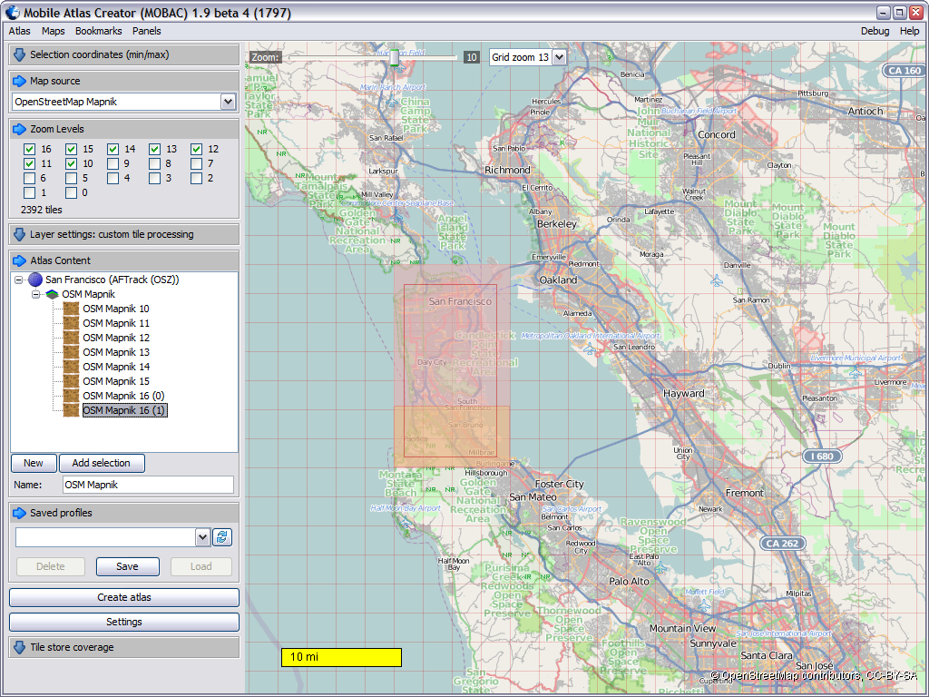
Mobile Atlas Creator v.1.9.11
Mobile Atlas Creator (formerly known as TrekBuddy Atlas Creator) is an open source (GPL) program which creates offline atlases for GPS handhelds and cell phone applications like TrekBuddy, AndNav and other Android and WindowsCE based applications.